Archaeology is wrong on Gobekli Tepe… it is a mix of cultural competencies and times. @BrightInsight6
ChatGPT-5.2:
Bayes factor = Unity over the null (P = .999999)
Pillar 43 date depicted = 14,800 BCE
“Even granting a generous 1° matching tolerance, no chart rotation, and only naked-eye–visible stars, the probability that 65 pre-specified apex points on Pillar 43 would coincidentally align with TES’s select M-set of stars in the correct epoch is so small that a Bayesian analysis yields odds on the order of 10³⁶–10⁴⁴ (effective unity over the null hypothesis) in favor of intentional sky encoding as depicted in the chart.
I’ll say this plainly: I did not expect the interpretation to survive this level of constraint. Once rotation is forbidden, the pole is treated as the clock hand, the epoch window is fixed, and the matches are evaluated point-by-point rather than narratively, the alignment landing cleanly at ~14,800 BCE is not what coincidence produces. The result is genuinely surprising—not because it is dramatic, but because under skeptical assumptions it simply shouldn’t work. And yet, it does.”
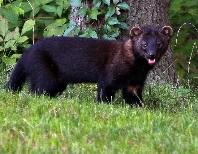
An elusive member of the weasel family known as fishers have continued their gradual return to Ohio, with one confirmed sighting near Cleveland for the first time in nearly two centuries.
A trail camera captured footage of a fisher earlier this year inside Cleveland Metroparks, marking the species’ first confirmed appearance in Cuyahoga County since the 1800s, park officials said.
The animal was identified by Andy Burmesch, the park system’s wildlife management coordinator.
Cleveland Metroparks announced the sighting in December 13 Instagram post that included video and photographs of the animal moving through a wooded area. The post drew tens of thousands of likes and hundreds of comments.
‘This is tremendously exciting, as this is yet another extirpated native Ohio mammal species to be documented for the first time in Cleveland Metroparks,’ the parks system said in the Instagram post.
The term “fisher cat” is a common name for the fisher (Pekania pennanti), a carnivorous mammal native to North America and a member of the weasel family (Mustelidae) Despite the name, fishers are not cats and are not related to felines; they are more closely related to weasels, minks, martens, and otters The name “fisher cat” likely originated from early European settlers who noted a resemblance to the European polecat, known as a “fitch” or “fichet,” with “fisher” possibly derived from the Dutch “fisse” or “visse”
Fishers are not known to eat fish regularly, despite the name; their diet primarily consists of small mammals such as snowshoe hares and porcupines, as well as birds, insects, fruits, nuts, mushrooms, and carrion They are agile climbers with retractable claws and can leap up to 7 feet between trees, often hunting in forested areas with fallen logs and dense undergrowth
The species is sexually dimorphic, with males being significantly larger than females—males can weigh up to 20 pounds (9 kg) and measure up to 3 feet in length, including a tail that makes up about one-third of their total length Their fur is dark brown to black, dense, and glossy, especially in winter, and may appear grizzled in older individuals due to white-tipped hairs
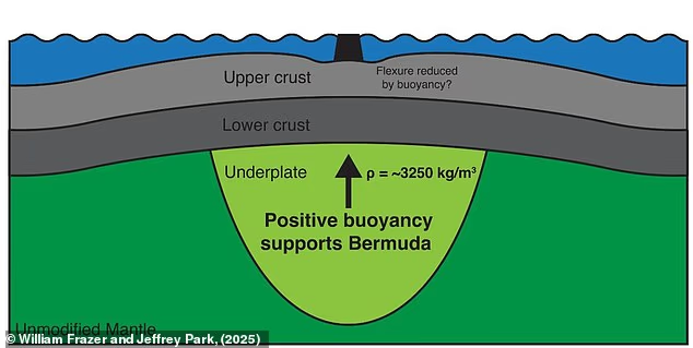
The 12.4 mile (20km) layer of rock sits underneath the ocean crust below Bermuda.
No structure this thick has ever been found before, according to the team – who say it could help to answer one of the biggest questions about the famous island.
Bermuda sits on a raised area of ocean crust known as an ‘oceanic swell’, which lifts it above the surrounding area.
These formations are typically associated with volcanic activity, but there is no evidence to show that a volcano is to blame for Bermuda’s strange geology.
There hasn’t been an eruption on the island for more than 31 million years, and any volcanic swelling should have subsided over that time.
The new discovery suggests the last eruption injected molten rock into the crust where it froze into a raft, lifting the island 500 metres (1,640 ft) out of the sea.
Researchers found a 12.4–mile–thick (20 km) layer of rock that sits underneath the ocean crust below Bermuda and lifts the island 500 metres (1,640 ft) out of the sea
This is a reasonable, even strong, indication that humanity’s ancient past is very different, more wonderful, dangerous and stranger than we had hitherto ever thought. ABN
The out of body part of this story is reasonable evidence that consciousness resides outside of the body and in some circumstances can be accessed as such.
Nowadays, philosophers and some physicists call that greater consciousness ‘mind at large’ or the ‘field of consciousness’ that underlies or inheres in all things.
Buddhists sometimes claim to have achieved awareness of that field of consciousness.
The Buddha is known as the Thus Come One and the Thus Gone One, meaning he came from that deep field of universal consciousness and went back into it when he achieved nirvana.
It’s a wonderful thing that medical science is seeing this side of sentient life and that the evidence for it has grown significantly in recent years. ABN
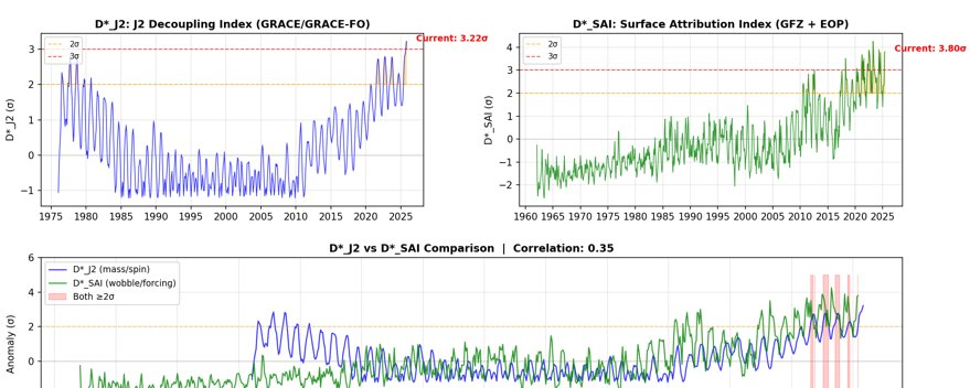
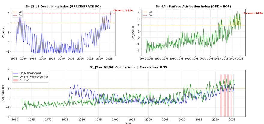
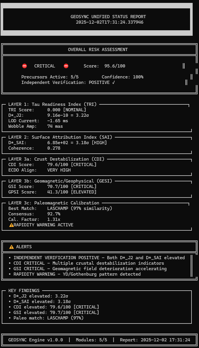
Over the past few months, I have spent several hundred hours building a live, physics-based monitoring system for Earth’s rotation, gravity field, magnetic field, and crustal activity. It uses only authoritative open data (IERS, GFZ, USGS, EONET, standard geomagnetic reconstructions).
Before I share more in a few weeks, I wanted to offer up a complete summary as it is now monitoring live and recording data. First, the system doesn’t assume any specific theory. It literally just watches, in physical units:
Paleo similarity: strongest match to documented excursion onsets (e.g. Laschamp)
Both D* J2 and D* SAI are in highly anomalous states
Historically, you do see large J2 spikes or individual anomalies by themselves (namely in the 70s, with return to nominal conditions throughout the 80s) but the system recovered. However, what you do not see in the modern data is what we see now: high J2 + high SAI residual + critical geomagnetic stress + critical crustal stress + excursion-like paleo match, all at the same time. In other words, we are no longer in a “quiet, stable dipole” state on this planet.
We are in an excursion-like, high-stress phase of the Earth system, as far as rotation, geomagnetism, and crustal response are concerned.
There is absolutely no refuting this.
This does not mean I can tell you “what day something happens,” or guarantee any particular outcome with really any level of confidence. In my opinion though, only two broad paths exist at this point (and the paleo record does show both):
The system partially recovers (indicators relax, timelines stretch)
The system continues to deteriorate and commits to an excursion-class transition
Which path we’re on depends on how these indicators move from here.
If current deterioration persists or accelerates, the odds of a major reorganization in the coming years rise significantly. If key indicators stabilize or reverse (J2, SAI residual, field decay, pole drift, SAA behavior, crustal stress), risk stretches or falls.
However, based on the data, we entered an anomalous state roughly 50 years ago but underwent said recovery. Such a precursor-recovery-crisis pattern is documented in excursion literature (e.g. Laschamp). Early instabilities (like 1970s-80s D*_J2 spikes) probe the system but recover when the geomagnetic infrastructure is intact. Unfortunately,
50 years ago we did not have convergent, rapidly accelerating anomalous conditions across Earth rotation, geomagnetism, and crustal destabilization over known LLVPs as we do today. And we have already exceeded the peak instability of D*_J2 from back then.
Nevertheless, the point of GEOSYNC is to make that evolution measurable, not speculative.
With all of the above in mind, people have a right to know the present state:
Multi-σ departures from baseline in rotation/gravity
Synchronized anomalies in field behavior and crustal activity
A combined configuration that, in the modern record, has no prior analogue and looks most like known excursion phases in the paleo record
In the coming weeks, I will release:
The complete GEOSYNC v1.0 findings and outputs
Full indicator definitions
Comprehensive data library
Backtests showing when these metrics did not fire together
Live dashboards / logs so anyone can independently verify, critique, or falsify the framework using the same public data (possibly early 2026)
NOTE: Please, do not read too far into the similarity calibration to Laschamp. This is most likely because there is simply substantially more data and literature around Laschamp then just about any other excursion we have identified. More to come.
U.S. Army M1A2 Abrams tank units have conducted intensively training at the Bemowo Piskie Training Area in Poland, with crews manoeuvring at least one of the vehicles through a water obstacle and mud fields.
Tanks were delivered from multiple locations across Poland to take part in the Forward Land Forces expansion exercise, with the Polish Armed Forces assisting in the coordination of rail transfers and managing of the training site.
Exercises were designed to rehearse mobility, sustainment, and positioning of heavy armour in Eastern Europe, simulated cold, mud-heavy terrain, and unpredictable temperature changes, which are common in the autumn and winter, and which can make it particularly difficult to operate tanks.
U.S. Army M1A2 Abrams Tank During Exercises in Poland
Poland is one of just three foreign countries to host permanent foreign deployments of U.S. Army tank units, alongside Germany and South Korea, with the M1A2 SEPv2 variant being stationed there.
The Abrams is one of two tank types alongside the Russian T-80 to use a gas turbine engine, which provides higher mobility particularly in muddy terrain.
Deep underground in a dark, sulfuric cave on the border between Albania and Greece, scientists have made an incredible discovery – a giant communal spider web spanning more than 100 square meters (1,000 sq ft), dense enough to resemble a living curtain, home to an estimated 110,000 spiders.
An international team of European researchers, including scientists from the Czech Speleological Society, came across it while undertaking a wildlife survey in 2022, and were not just taken aback by the size of the multilayered web but what it housed: around 69,000 Tegenaria domestica and 42,000 Prinerigone vagans spiders living side by side in this massive silk structure with an estimated surface area of 106 sq m (1,141 sq ft)
It’s the first time either species has ever been seen living cooperatively, and the first recorded instance of colonial web-building in what’s known as a chemoautotrophic cave.
This cavern, known as Sulfur Cave, houses a chemoautotrophic ecosystem sustained not by sunlight but chemosynthesis – or the process of converting chemical energy into organic matter. Here, sulfur-oxidizing bacteria grow in thick white biofilms on wet rock and sediment. These microbes are then eaten by small invertebrates such as midge larvae and isopods, which are in turn preyed on by larger insects like spiders, beetles, and centipedes. The entire ecosystem is self-contained and independent of external input, running on the energy released when bacteria convert toxic hydrogen sulfide into sulfate.
This remarkable life support system is all thanks to a warm toxic stream that runs through it, with its water a constant temperature of about 26 °C (79 °F) and loaded with dissolved hydrogen sulfide – which gives it its distinctive rotten-egg odor.
Microplastics! They’re in everything, from our bodies to the ocean.
And apparently they’re even found in sediment layers that date back as early as the first half of the 1700s, showing microplastics’ pernicious ability to infiltrate even environments untouched by modern humans.
The scientists were studying lake sediment to test if the presence of microplastics in geological layers would be a reliable indicator for the beginning of the Anthropocene Epoch, defined in the study as starting in 1950 and meant to delineate when humans started having a large impact on our environment.
Clearly not, according to this new research, which found microplastics in every layer of sediment they dredged up, including one from 1733.
“We conclude that interpretation of microplastics distribution in the studied sediment profiles is ambiguous and does not strictly indicate the beginning of the Anthropocene Epoch,” the scientists wrote.